Wild woman
Friends, countrymen, I come not to throw ![[livejournal.com profile]](https://www.dreamwidth.org/img/external/lj-userinfo.gif) ginkgo off a cliff, but to praise her...
ginkgo off a cliff, but to praise her...
Today we went on a hike with a couple other folks I met rock climbing. We should have known better when we found the trail was up Breakneck Mountain. They're not kidding.
"The navigation once you locate the trailhead is equally simple, since if you deviate much from the rock ledges that comprise most of the trail, you'll fall hundreds of feet down the mountain's south face." gorp.away.com
"A demanding hike up the steepest and most exposed scenic trail in the Highlands, with sustained views from open ridges and returning through quiet forests. The steep windswept spine of Breakneck Ridge is considered the most difficult and rugged ascent in the Highlands. Rising from nearly sea level on the Hudson at Breakneck Point, to 1,100 feet on Breakneck’s summit in less than 0.5 mile, it is a rock scramble requiring an all-fours approach. Because the sheer southerly face of Breakneck draws very close to the trail in spots, this hike is not advisable in wet or icy conditions, or even in periods of high winds—and it’s not a good choice for unfit hikers or ones with bad knees. This is an aerobic workout of intense effort, and most hikers will find that they haven’t carried enough water (trail leaders for the Appalachian Mountain Club generally require that participants carry 2 liters, minimum, on hikes of this nature)." trails.com
Example trail shot:

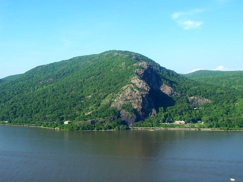
Long shot - yup, we started out at that building on the lower left, and went right up the top of the cliff face to the top:
Topo Map We started at Breakneck Point on the Hudson River (2/3 down on the left side) - by the third star on the W trail, we were ~900 feet up. By the fourth, >1100. Followed W up to the R trail (Breakneck Bypass) which was a steep slide down to Y, (Wilkinson), where it turned into a nice walk out. Total distance, ~ 3mi. Yeah, that's a steep ascent.
Here's a shot from the second star on the topo map... be sure to pan right to see the river that we started at, less than a third of a mile back.
I've been getting pretty decent at rock climbing - there were places that gave me pause. This was a hands, feet, and knees climb in the technical sense, several places were easily a 5.2-5.3. I'm in decent shape - I was winded, dehydrated, and sore by the end of it.
ginkgo made the whole damned thing. I couldn't be prouder, and since I know she's not going to crow about it, I'm going to.
You rock, hon.
Today we went on a hike with a couple other folks I met rock climbing. We should have known better when we found the trail was up Breakneck Mountain. They're not kidding.
"The navigation once you locate the trailhead is equally simple, since if you deviate much from the rock ledges that comprise most of the trail, you'll fall hundreds of feet down the mountain's south face." gorp.away.com
"A demanding hike up the steepest and most exposed scenic trail in the Highlands, with sustained views from open ridges and returning through quiet forests. The steep windswept spine of Breakneck Ridge is considered the most difficult and rugged ascent in the Highlands. Rising from nearly sea level on the Hudson at Breakneck Point, to 1,100 feet on Breakneck’s summit in less than 0.5 mile, it is a rock scramble requiring an all-fours approach. Because the sheer southerly face of Breakneck draws very close to the trail in spots, this hike is not advisable in wet or icy conditions, or even in periods of high winds—and it’s not a good choice for unfit hikers or ones with bad knees. This is an aerobic workout of intense effort, and most hikers will find that they haven’t carried enough water (trail leaders for the Appalachian Mountain Club generally require that participants carry 2 liters, minimum, on hikes of this nature)." trails.com
Example trail shot:
Long shot - yup, we started out at that building on the lower left, and went right up the top of the cliff face to the top:
Topo Map We started at Breakneck Point on the Hudson River (2/3 down on the left side) - by the third star on the W trail, we were ~900 feet up. By the fourth, >1100. Followed W up to the R trail (Breakneck Bypass) which was a steep slide down to Y, (Wilkinson), where it turned into a nice walk out. Total distance, ~ 3mi. Yeah, that's a steep ascent.
Here's a shot from the second star on the topo map... be sure to pan right to see the river that we started at, less than a third of a mile back.
I've been getting pretty decent at rock climbing - there were places that gave me pause. This was a hands, feet, and knees climb in the technical sense, several places were easily a 5.2-5.3. I'm in decent shape - I was winded, dehydrated, and sore by the end of it.
You rock, hon.
Re: This fisherperson, tell me more...
Then come home and remember that the world *deserves* its frigging problems, so it can just stew in them. :)
Re: This fisherperson, tell me more...
Re: This fisherperson, tell me more...
Re: This fisherperson, tell me more...
;)